


- WIADOMOŚCI
- ANALIZA
How to Destroy (and Protect) Underwater Pipelines? [ANALYSIS]

The damage done to the Nord Stream pipelines in the Baltic Sea has shown that underwater systems and structures are fairly exposed to attacks, also during peacetime. One should get ready to protect them, and destroy them as well, also in the territorial waters of the adversaries. Poland needs to protect these assets, due to the fact that the Norwegian-Polish-Danish Baltic Pipe pipeline crosses the Russian Nord Stream pipes at one, specific location.
It is quite probable that damage inflicted on both Nord Stream pipelines has been caused by the Russian Federation. The underwater explosions detected near Bornholm show that detecting the cause of such damage is very challenging, and time-consuming while playing the blame game is simply a waste of time.
On the other hand, one should also point to the "positive" ramification of damage. First, the decision-makers have finally realized that undersea pipes may be exposed and vulnerable. Thus, they also need to be protected, not just thanks to the confidentiality associated with their location. Secondly, everyone now understands that the enemy infrastructure at the sea bottom may be as important as the critical infrastructure on land. Thus, one should be ready to destroy these assets, also in the protected, foreign territorial waters.
How to supervise and protect underwater infrastructure?
For many years, the fact that underwater systems remain at the bottom of the sea has been considered to be the main factor contributing to their security. The depth guaranteed that it would be very difficult to pinpoint the exact location of the pipeline. Secondly, one could always monitor the activities of the surface vessels looking for “something” in the sensitive waters. It was clear as to when the assets underwater may be threatened.
Sonar and unmanned technologies are advanced enough to overcome the natural barriers related to depth (pressure increase, low temperature, variable water parameters, darkness). The sea bottom may now be mapped as accurately, as the land areas. Furthermore, modern robotics also make it possible to conduct underwater operations remotely, without any need to have divers involved. One may build, repair, control, or destroy underwater structures.
The growing transparency of the deep sea is evident, and it is proven by the number of historic shipwrecks that have been found over the last few years around the world, in massive quantities. Meanwhile, the inability to use precise radar and optical systems underwater is no longer an obstacle (using the EM spectrum), with the same statement applying to sonar (hydroacoustic systems using mechanical waves).
Seas and Oceans are vast enough to make the process of accurate mapping much slower, as opposed to the land areas. However, examining a specific, designated water body is no longer a challenge - this may be done through the collection of acoustic imagery of the sea bottom, with resolutions brought down to a few centimeters. Therefore, it is possible to find a specific element of the underwater infrastructure, and it is also feasible to monitor its status via external surveillance and regular monitoring and identification of sudden anomalies. Information that a new object has appeared near the underwater cable or pipeline may be a cause for concern.

Photo. www.atsb.gov.au
This is currently the easiest way to monitor and protect the elements of underwater infrastructure. This method makes it possible to avoid the creation of a special-purpose protection system for the pipelines for instance. It should then be maintained, supervised, and serviced - this, also, can be avoided. Periodic surveillance replaces such systems. Activities as such may be assigned to surface vessels - manned or unmanned, or submerged assets, such as variable depth sonars, submarines, and autonomous, or remotely controlled underwater vehicles.
A submarine is the most efficient tool for deep underwater search operations. However, this asset is expensive and difficult to deploy in hazardous waters that were not searched beforehand. There is a possibility of sea mines being used in the area of concern for instance. Furthermore, sonars of the submarines have been designed with a different purpose in mind - they are not a proper tool for creating high-definition maps of the bottom.
SAS sensors (Synthetic Aperture Sonar), the latest generation of sonar systems, are much better at doing that job. They guarantee resolution in the centimeter range, with imagery being comparable to a standard photograph. In the past, to obtain imagery of such quality one needed either large antenna arrays (hence it was impossible to use small vessels as the carrier platform), or very short wavelengths (with a very short range as well).

Photo. M. Dura
As SAS sensors have become common, along with modern computing technologies, the situation has changed. The antenna arrays were miniaturized, and they could have been embedded in small towed vehicles, and on unmanned underwater platforms. The resolution of the sea bottom imagery became high enough to detect objects that were previously unknown, even in very shallow waters, theoretically well-examined.
A good example of that is the discovery of the remains of the German SM UC-69 submarine in late October 2017. The wreck, sunk on 6th December 1917, was discovered by the Dutch HNLMS “Makkum” (Tripartite-class) Mine Countermeasures Vessel. The wreck was found 8.5 NM from the French Barfleur harbour in Normandy, in the French territorial waters, supposed to be well-known
The new technologies are a major asset for oceanographers, historians, and undersea archaeologists then. SAS sensors also brought an entirely new set of capabilities into the realm of military and special operations. Groups of small vessels can be used in activities as such.

Photo. ThayerMahan, Inc. Kraken Robotics, and the NOAA Office of Ocean Exploration and Research
The choice of the surveillance asset used depends on the depth, at which the given underwater asset finds itself. At smaller depths, surface vessels are used as the sensor carriers, with the arrays placed under the hull, or being towed. A system as such allowed the Polish Santi explorers team to find the Royal Navy's HMS „Narwhal" submarine wreck. The fragmented hull of the British sub was found 94 meters deep.
The use of similar assets has not been successful during the search for the Argentinian ARA “San Juan” submarine, lost at sea on 15th November 2017. The wreck located at the depth of 800 meters was impossible to detect from the surface, despite the involvement of 4,000 persons, 28 vessels, and 9 aircraft from 19 nations in the search operation.

Photo. US Navy
It was only possible to find the Argentinian submarine when the search party was joined by a specialist Ocean Infinity’s “Seabed Constructor” offshore industry support vessel in September 2018. The vessel was equipped with Kongsberg Maritime Hugin AUVs, fitted with multibeam and SAS sonars. The Hugin AUVs have found the ARA “San Juan” submarine wreck that was then positively identified by an underwater robot.
This is not unusual. Unmanned platforms, autonomous and remotely controlled ones, turned out to be the best means for checking the state of the seabed. Manned vehicles are a dead end in this domain for now, with their limited autonomy caused by the necessity to provide life support systems onboard. They are also quite hazardous to use.

Drones do not have any of those deficiencies. They may work below the depth of 10,000 meters, for many hours. Hugin may move through the water at a speed of 3 to 4 knots for more than 24 hours. AUVs (Autonomous Underwater Vehicles) that can work autonomously in a given area are especially useful, as the search for the ARA "San Juan" has shown. To supervise the underwater infrastructure, it's enough to have vessels capable of supporting AUV operations, with a proper mission bay, and a ramp needed to lower the drone into the water.
Deep water cable ROVs are a complementary measure here, and they can be used to ultimately identify the anomalies (new, suspicious objects in the vicinity of the cables or pipelines), with the use of cameras and manipulator arms. These robots may use an umbilical cable for power supply, so theoretically they could stay underwater forever. Furthermore, real-time data feed is available, so response times are shorter, should a threat be detected.

Photo. M. Dura
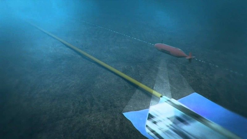
These robots may either detect or create the threat. They may be used for sabotage, by delivering explosives and placing them close to the underwater structure.
How one can destroy underwater structures?
An attack targeting the underwater infrastructure may be as effective as an airstrike targeting a land-based element of critical infrastructure. More importantly, it is possible to conduct an attack as such in a much safer manner, long before the conflict breaks out, and without any possibility of being blamed for the act in question. Finding a Russian-made explosive close to a gas pipeline, or an undersea telecom cable is not a final piece of evidence pointing to the perpetrator (unless the perpetrator is caught red-handed).

Photo. mil.ru
Theoretically, it is really simple to conduct an attack as such. First, one needs to locate the given underwater structure. This may be done in an entirely overt manner, during an oceanographic survey. Thus the Americans could only have filed in ineffective protests, when their coast was approached by the Yantar Krius-class 22010 research vessel of the Russian Navy, sailing in areas where underwater optical fiber cables were placed. In the case of the Nord Stream pipelines, the Russians knew exactly where they are, and where the best location for the attack was. The search stage could have been omitted.
Planting the explosive charge is not a problem as well. No manned assets or divers would be required here. It would be enough to use drones that not only would deliver the explosive, but also cover it with sand, to camouflage it. Contrary to what one may think, there is no need to use cable-controlled robots for that purpose - they are slower, and need to work in sync with their mothership on the surface. Recording the presence of such a vessel in the area where the act of sabotage took place would make it possible to immediately indicate the perpetrator.

Photo. M. Dura
To avoid that, torpedo-like unmanned underwater vehicles could be used, being able to move further away from the mothership, with no cable connecting them to that vessel. The Germans have used a solution as such in their SeaFox minehunting UUVs. These vehicles can be defined as cable-operated explosive charges that are tasked with destroying sea mines once they hit them.
It is, however, a costly way to operate. Hence, when a necessity emerges to destroy a smaller object, Cobra attachment may be used on the SeaFox (15% of the cost of the carrier platform), made out of aluminum and composites and housing an explosive charge. It is left at the bottom and then detonated, remotely, or with a delay. SeaFox drone equipped with that armament may be used more than once. Nothing is standing in the way for a solution as such to be used on larger AUVs, such as Hugin or Remus, offering longer endurance, and greater levels of autonomy.
And again, the Russians did not have to hide their planting of explosives near the Nord Stream. They could have done this as the pipeline was being laid, or during inspection or maintenance works. An explosive as such is virtually undetectable on an underwater structure supervised by the Russians - it could have been detonated with a delay, or with the use of a specific acoustic signal.

Photo. M. Dura
Preparing an operation as such, or getting ready to protect the underwater infrastructure of its own, Poland does not have to begin from a scratch. The Polish Navy operates Klein 3000 towed side-looking sonar arrays, and SAS sensors, on Gavia and Hugin AUVs used in minehunting.
The Polish Navy also operates delivery systems that could be used to plant the underwater charge near the desired target. Toczek underwater charges, detonated acoustically, Głuptak single-use drones, or cable-operated ROVs could be useful in such a scenario. Based on those experiences, a monitoring and response system for the Baltic Pipe could be created, offering a capability to prevent incidents similar to the ones happening to both Nord Stream pipelines in late September 2022.
There is a lot of learning material available, since monitoring the status of the undersea structures with the use of AUVs is a common practice. Back in 2018 Swire Seabed announced that it has inspected Equinor's underwater pipelines, with the use of Hugin AUV - similar to the one used on the Polish Kormoran II MCMV. That inspection concerned three pipelines between the Norwegian town of Kollsnes, and the Troll A drilling platform. 180 kilometers of pipeline were inspected, over the course of just two dives.
As it turned out, data gathered by the AUVs had quality identical to data gathered during the standard inspections (involving underwater vehicles with cameras for instance), but the whole task was completed 6 times faster. During the operation, the drones underwater were accompanied by a small vessel used to update the AUV's position, and in a role of a relay, between Hugin, and the Bergen Office of Swire Seabed, which hosted the control center.
Fugro Survey AUV is another company that conducts pipeline inspection operations, with the use of underwater vehicles. It used the Echo Surveyor III AUV (Hugin 1000 adopted for conducting operations below 3,000 meters) to conduct an underwater survey for Brunei Shell Petroleum Co. in December 2019.


