


- ANALIZA
Space Technologies for the Polish Security?
Developed countries mass-use satellites to perform tasks related to crisis management, increasing the level of safety for the citizens, with consideration being given to the growing number of catastrophes or natural disasters. Is the Polish space sector ready to respond to a demand as such? Does demand as such actually exist in Poland?
For the purposes of crisis management, a variety of services and government administration bodies may utilize satellites. This could happen within all three basic domains where these systems are useful - Earth observation, navigation and positioning and communications.
Remote sensing data derived from the satellite imagery is a perfect source of information pertaining to the area of interest. The data in question may be used to monitor spreading of fire, in case of major wildfires. The data also makes it possible to monitor the river waters, in case of floods. Earth Observation satellites allow the crisis management personnel to examine landslides or collapsing buildings in detail. Many of those tasks may also be carried out with the use of satellites fitted with a SAR (Synthetic Aperture Radar) sensor, instead of cameras. Thanks to systems of this class the satellites may be used to observe the given area regardless of cloud cover or time of the day.
Ability to utilize satellite imagery is an area where satellite technologies could be used. The above is implemented on the basis of a memorandum concluded in 2012 by and between the Chief of the State Fire Service and the Space Research Centre of Polish Academy of Sciences, pertaining to the expert support the SRC could provide in the process of acquiring, sharing and analysing the satellite imagery. As a result of collaboration as such, analytical studies have been prepared covering the issue of analysing the situation during the floods.
Meanwhile GNSS satnav systems make it possible for the rescue services to rapidly and precisely define the location where disasters or accidents are taking place. At the same time, the crisis management personnel gains access to a tool for monitoring the traffic of the vehicles involved, which makes it possible to select optimal routes, considering the emerging circumstances. Fusing the benefits stemming from use of satellite navigation systems with spatial information and remote sensing technologies is a common and mass practice in case of natural disasters response.
Fusion of communications and positioning, coming in a form of the Cospas-Sarsat solution, is an interesting, yet relevant application as such. This is a thing that tells the rescue crews where the disaster has taken place. If a ship is sinking, or an aircraft hits the ground, then Cospas-Sarsat transmitter is automatically turned on, passing the information on to the satellites. Today it happens almost in real time. We have a transmission of positioning data provided by GNSS and even a return channel for radio communications. This service is offered, among other platforms, by the Galileo satellites.
“This works on a global scale. If a disaster takes place in a remote location, regardless of that, the signal reaches the rescue services almost immediately. There is also an option of establishing a simple communications link. Thanks to the above, the help reaches the ones that need it in a more rapid manner. Here we are referring to several thousand people globally who, thanks to the above, have received help in a quicker, more efficient and more effective manner” – Ryzenko explains.
Indeed, satellite communications play a major role in rescue operations. Above all, communications as such may be used in locations where there is no access to conventional cellular network services. Satellite phones may also be used in case when telephone network cabling and mobile network base stations, antennas and other required infrastructure is destroyed. Here we are referring both to phone conversations, as well as to data transfer tasks.
Another area is the use of satellite communications. Here we are referring to a mature use of technical solutions available on the market. We have command vehicles used by the State Fire Service, deployed in circumstances of serious crises, forming a command point. There, a satellite antenna may be usually found on the roof, as in case of outside broadcasting vehicles.
Key Meaning of Awareness
Potential benefits stemming from the use of satellite technologies for crisis management purposes can be seen influencing the policy of European Commission. Therefore, European framework programmes, including FP7 or Horizon 2020, could be used to get funding for the related projects. Here it is, above all, all about a proper flow of information. It remains relevant that the needs the administration may have, within the scope of remote sensing or satellite data, are taken into account by companies that remain capable of delivering adequate solutions in a commercial manner, to meet the requirements.
POLSA's survey carried out in 2018 also had a purpose of raising the awareness. The survey was to define the competencies and requirements the public administration bodies may have, with regards to the use of satellite data in operation of public bodies. The information pertaining to the survey was received by hundreds of entities, ranging from local authorities to the central governmental administration and the subordinated bodies. Until November, POLSA received more than 600 replies. The data gathered thanks to the survey will be utilized in the Agency’s work on a training programme addressed to the administration. This refers to enhanced competencies, within the scope of using the satellite data in daily work, and within the scope of making it easier for the decisionmakers to interpret the data provided by the satellite technologies, and thus making informed decisions.
Entirely New Possibilities
The ability to make use of the satellite infrastructure for crisis management purposes yet again has grown, as two broad European programmes listed below have recently been launched: COPERNICUS and GALILEO.
The former one, Copernicus, is focused on satellite imagery of the Earth accessible free of charge. The space segment of the Copernicus system consists of a number of sensors dedicated for a variety of tasks, including Ocean research, air analysis or afforestation analysis. The data is gathered by Sentinel satellites developed specifically for that purpose, among them one may find both optical as well as radar observation systems.
The satellite data gathered through observation activities remains very important in crisis management, however it is still a challenge to share it on time and in a manner that would be useful during the rescue operations, when every hour or even every minute counts.
Data acquired by other satellites is also gathered within the framework of the Copernicus programme. This includes commercial satellites, as well as the ones involved in the US Landsat network. Certain and rapid access to the data is possible thanks to services such as the Copernicus’s Rapid Mapping solution. The tool in question makes it possible to obtain geospatial information on demand, immediately after a disaster or accident, to support the crisis management operations. The service is based around rapid acquisition, processing and analysis of satellite imagery and other sources of geospatial and vector data.
Galileo, on the other hand, is a constellation of global positioning satellites. The signals coming from those MEO satellites make it possible to precisely define position of systems, cars or people using a proper GNSS receiver. Alongside positioning, Galileo satellites’ accurate time measuring capacity may also be very useful. Following the achievement of Fully Operational status, defining the position with the use of the Galileo network is to be much more precise, than it happens in case of the US-made GPS system.
State Fire Service, carrying out the tasks imposed by the law, makes use of the broadly understood satellite technologies. Using navigation applications that are functionally integrated with a decisionmaking support system that could be used to receive alerts and manage the assets involved is the most common field of application for solutions as such. Considering the ongoing work related to creation of the Decision Support System of the State Fire Services, the functions in question will be, soon enough, implemented via this system.
Both Galileo, as well as Copernicus, are a source of a number of benefits for the rescue services and government administration responsible for crisis management activities. In case of sudden natural disaster, satellite imagery of the event location remains very desirable, and this refers to images that would present the area before and after the event. On the basis of that imagery one may assess the changes in detail, with regards to the given area. Thanks to the above scale of destruction or losses may be estimated, for instance in the area of agriculture.
Practical Benefits
Across a short timeline, in case of rescue/crisis response operations, the rescuers that have satellite systems at their disposal, have numerous advantages at hand. Above all, the services get in-depth situational awareness of what is happening in the given area, on the basis of the satellite imagery.
In case of forest fires, one may get an idea of the speed and directions in which the fire spreads. the recent wildfires in northern California are a perfect example here, happening in the San Francisco area. Not only did the services make use of satellite imagery to track the fires, but data acquired in this way will also be used to restore the affected areas. NASA has shared a special purpose tool designed to assess the status of the foliage, type of the soil or simply, level of destruction within the given area. For that purpose imagery gathered by the Landsat satellites is being used, among other information.
In case of a flood, the firemen get an insight in where the water level grows rapidly. Factors such as the rising waters may be effectively monitored with the use of satellite-borne SAR sensors, thanks to which the data regarding this matter may be gathered regardless of time or cloud coverage.
GNSS technologies may be used by the crisis management staff to better manage own resources and personnel, including e.g. the fleet of vehicles assigned to the given area/task.
However, the use of satellites in crisis management may also be viewed along an extended timeline. By indicating the dry areas in the summer one may accurately forecast the fire risk and thus implement proper preventative measures in those areas. Meanwhile, when it comes to floods, the satellite imagery may be used to create maps that would indicate the area that could potentially be flooded in the future. The inhabitants of those exposed areas may receive suggestions to move or, at least, get an evacuation order early enough, should a threat emerge. Satellite maps may also be used to designate high-risk areas that could be affected by a flood or by landslides, where administrative ban on erecting residential buildings could be implemented.
Proper Expertise
A number of Polish companies and research bodies remains in possession of proper know-how, required to make use of satellite technology in crisis management. This, in particular, pertains to proper acquisition and processing of the satellite imagery, to derive the most desirable information from that imagery.
– “This concerns enhanced use of satellite and space technologies used in state management, both in the field of defence, in the field of crisis management, as well as in civil use of data for the purpose of state management” - stated Robert Nowicki, in his interview for Space24.pl. Nowicki is the Deputy Director at the Innovation Department of the Ministry of Entrepreneurship and Technologies.
Readymade Solutions
Numerous products and services tied to use of satellite data for crisis management purposes have already been developed with financial support provided by the National Centre For Research and Development, ESA, or the European Commission. Modern solutions as such were also being intensely worked on by Astri Polska. The said company generates all of its income on the basis of activities undertaken in the broadly understood space domain.
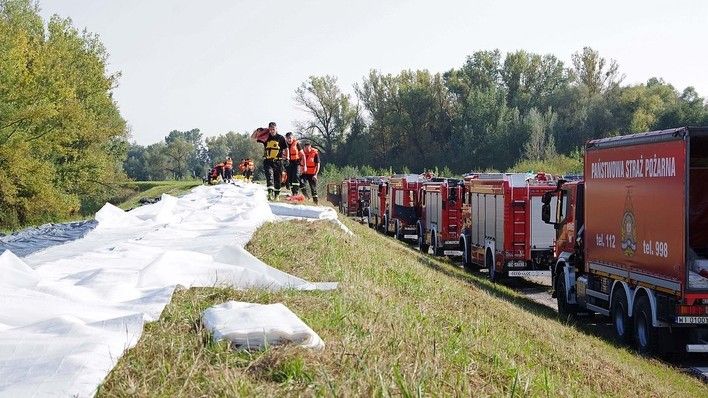
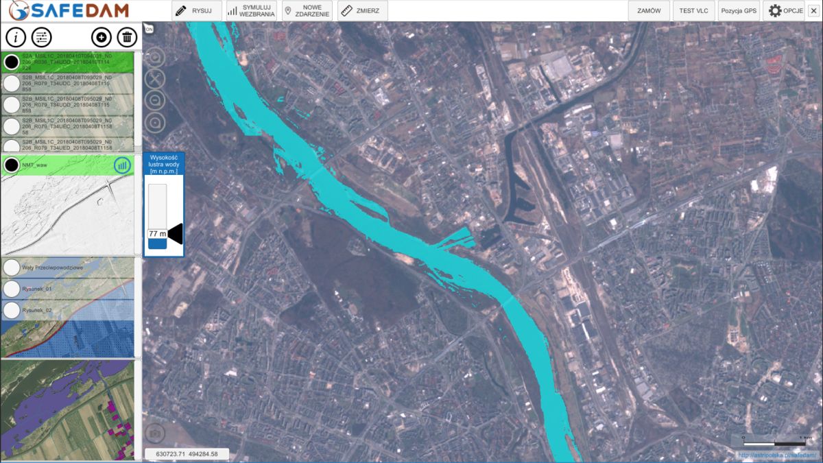
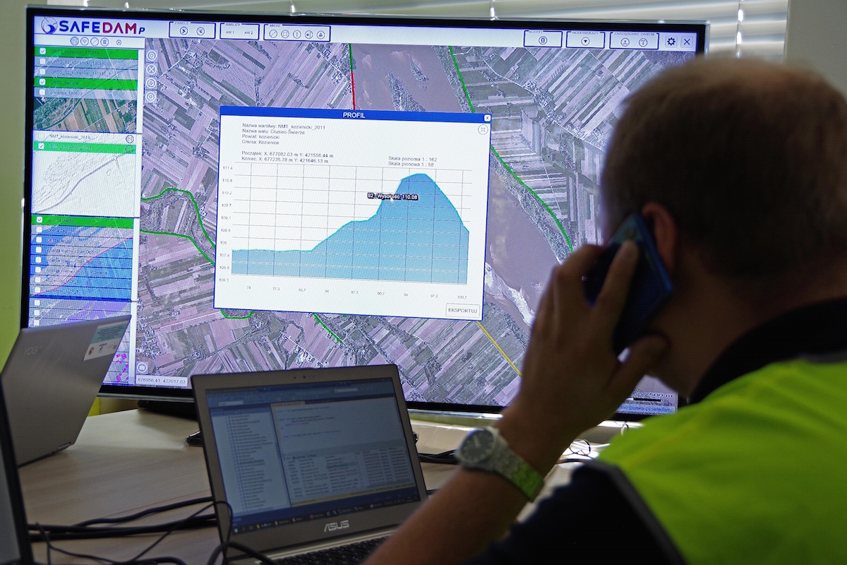
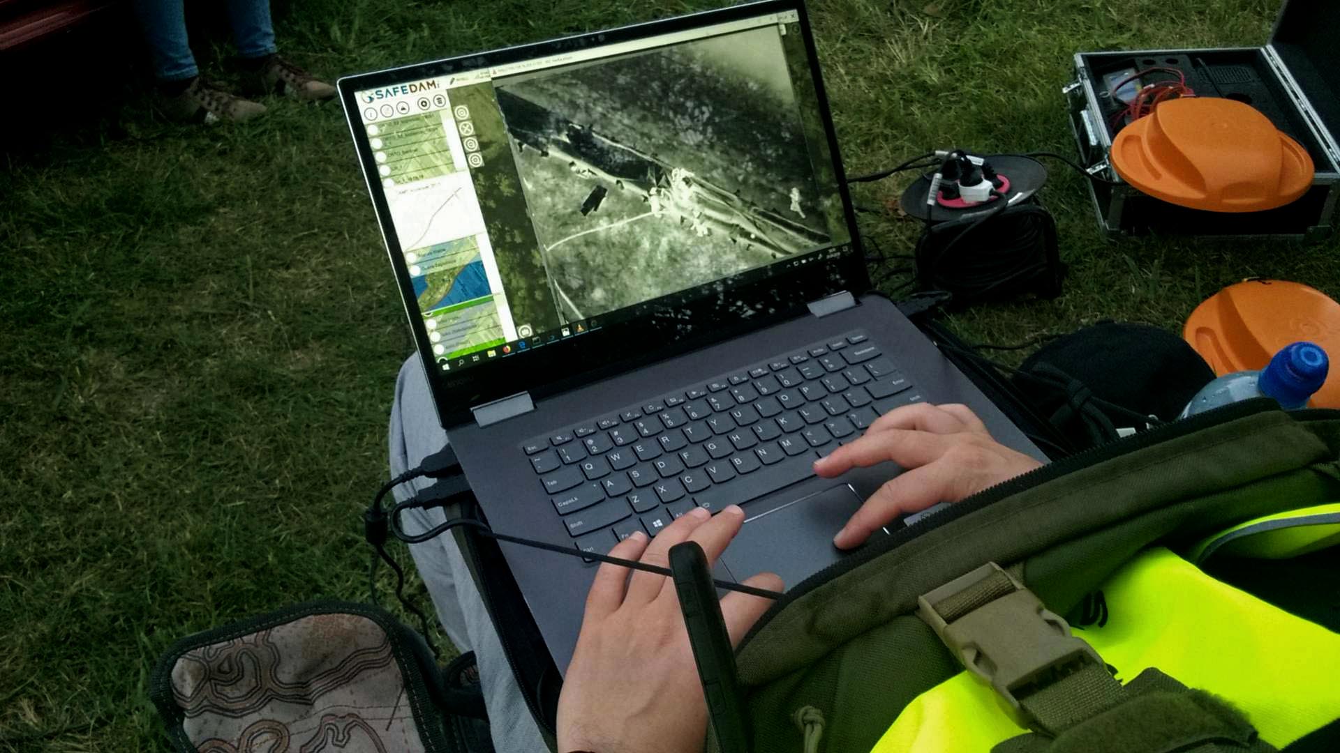
SAFEDAM is a good example of a product as such. This is an innovative system designed by the Polish engineers for the purpose of monitoring flood embankments. Satellites-provided data is fused, within this system, with data acquired by using drones and aerial imagery. In case of a flood threat, the system makes it possible to monitor the flooded area 24 hours a day. Sentinel constellation imagery is then used to automatically present the reach the floodwater has. Free-of-charge satellite data is also enhanced with high-resolution commercial imagery (Pleiades, SPOT and TerraSAR-X/TanDemX satellites). Data is visualized in 2D and 3D modes.
Read More: Modern System Used by the Firefighters. Satellites and Drones Helpful in Flood Prevention
What’s relevant, the system may be configured in two manners: preventative and intervention settings are available. The solution was being developed with active involvement seen on the part of the Polish firemen. They were consulted, when the system was in its infancy. Furthermore, the State Fire Service specialists already had a chance to use SAFEDAM in a practical exercise scenario. This means that they know the system, and thus it may be rapidly deployed.
Within the framework of Earth Observation for Eastern Parnership [EO4EP] project pursued by ESA and the World Bank, Astri Polska has prepared a tool that could be used to monitor ice cover on the rivers. Ice on the rivers is a frequent a cause of floods.
River ice cover monitoring system developed by Astri Polska delivers the relevant information on the current status of the rivers. As radar satellites are utilized for that purpose, the required data could be gathered regardless of the cloud cover or time of day.
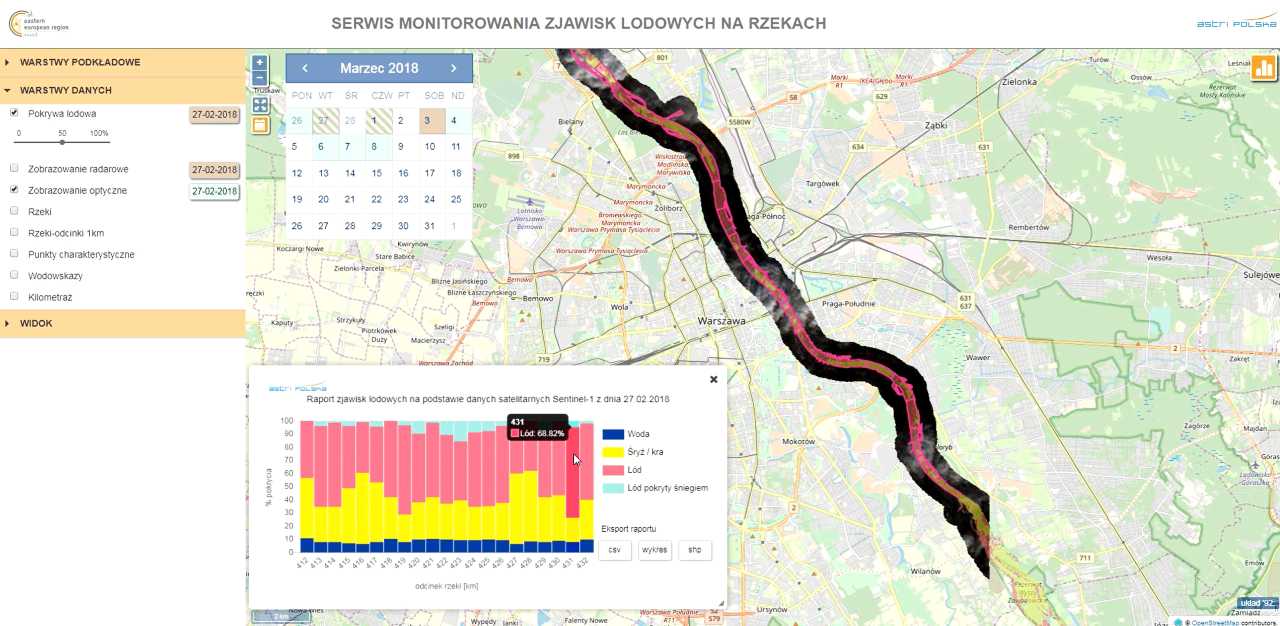
As stressed by Beata Weintrit who coordinates the EO4EP project at Astri Polska: “Our system’s use of the free-of-charge data, derived from the European “Copernicus” satellite EO programme is its major advantage. Thanks to the above the user does not bear extra costs stemming from gathering of the new data. Furthermore, the accuracy of gathered data reaches up to 90% which means that the presented data is credible.”
Flexibility and Purposefulness
Solutions for the services proposed by Astri Polska constitute a response to the actual market needs. This is because these solutions have been developed in close collaboration with rescue services, firemen or experienced policemen. The basic purpose of the applications presented is to raise the situational awareness in case of the personnel involved in the given operation or intervention, with a special attention paid to the persons leading and managing the operation. Information makes it possible to make accurate decisions.
A large quantity of information delivered on time and in a proper format, reaching proper people, may, in fact, have an impact on effectiveness of the decisionmaking process. Better decisions based on better information translate into limited damage and quicker restoration of relatively normal reality for the people affected.
Thanks to skillful use of modern technologies decisions that are of key importance for health and lives may be taken by proper factors, on the basis of complex, coherent and relevant data. This bears a high degree of relevance, Ryzenko explains, as crisis management has a meaning that is much broader than the semantic field covered by the term of rescue system. A proper assessment of situation is of key importance here, along with decisions made at the strategic level. Effective collaboration of a variety of public services is also an important element of this process.
When designing our solutions for crisis management purposes we take a great care of the flexibility of theirs. This factor will make the given application adaptable to the reality of work undertaken by the individual services. In this way, an application designed for the Police may be easily adopted to meet the needs of the Fire Service. This makes it possible for us to deliver products tailored to the individual requirements of a variety of users, without generation of extra cost entailed by designing the application from a scratch. All of the above contributes to the fact that the solution of ours enjoy a lot of interest, in case of the relevant services.
One of the key elements that complement the development and implementation of new crisis management solutions is seen in proper user and decisionmaker training processes. The above pertains to the analytical skills related to processing of major quantities of data and effective use of results obtained through the use of modern technologies.
During our long-running collaboration with the services subordinated to the Ministry of Interior and Administration, we have identified significant needs in the area of readying the public administration to carry out crisis management activities. Responding to that requirement we have developed the EvA Maps Training application used during the training activities addressed, primarily, to the public administration.
EvA Maps Training system has been based upon the functionalities developed by Astri Polska for the purposes related to the earlier map applications. The system is also founded on the experience gathered when working on European crisis management projects, and needs and expectations identified, when working with the public services and administration in an ongoing manner. Multimedia training is based on virtual crises placed in a realistic geospatial context, relevant for the given administrative body or generated on the basis of representative data contained within the resources available to Astri Polska.
Easy Implementation
We are happy, as Poland, to be in possession of high quality of expertise and experience gathered by the experts, in the area of using EO, Sat-Nav. and comms applications. Domestic companies, such as Astri Polska, have the relevant know-how and technological potential at their disposal, that could be used to create products and services of high quality, perfectly fitting the modern trends in the area of crisis management.
The required tools have already been proven during numerous exercises and training operations involving the domestic and international rescue services. The services in question have also been present when those innovative crisis management applications were being developed. Therefore Police or State Fire Department had no problems with rapid implementation of those modern solutions. This, at the same time, does not need to entail high cost for the state budget.
EU member states, Poland included, have been using very modern security solutions based around satellite technologies for years now. Thanks to programmes such as EO4EP or the SAFEDAM project Poland is capable of developing and bringing in added value to this European puzzle. Maybe it is high time for the administration to begin a broader implementation of solutions as such domestically. Drought, wildfires or floods may happen anytime. Instruments that could be used to support effective monitoring and minimize the potential damage are ready to be implemented.
The article has been written with support provided by Astri Polska


